Intro
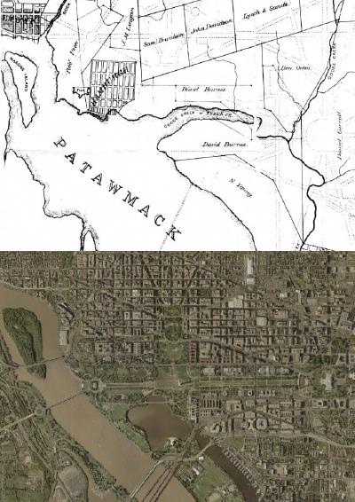
Good evening, I am your host Karen Hudes in this series on the Network of Global Corporate Control. Two days ago a fan suggested that we devote a show to the owners of the land beneath Capitol Hill. The fan sent me these early maps. The first map showed that a tributary of the Potomac River (which was named by Native Americans), was also called "Tyber Creek". The new Americans were going to have to make an effort to escape from ties to Rome: s3.amazonaws.com/khudes/dctvteleprompt8.23.16.3.pdf

Capitol Hill and POPE Francis
Originally called 'Goose Creek', it was renamed by settler Francis Pope. Pope owned a 400-acre (1.6 km2 ) farmstead along the banks of the creek which, in a play on his surname, he named "Rome" after the Italian city, and he renamed the creek in honor of the river which flows through that city. It was southeast of then Georgetown, Maryland, in the middle of lands that were selected for the City of Washington, the new capital of the United States. It flowed south toward the base of Capitol Hill, then meeting the Potomac near Jefferson Pier. Some of the land next to Francis Pope's farm was owned by Daniel Carroll (July 22, 1730 – July 5, 1796). Carroll was a politician as well as a member of one of the United States' great colonial Catholic families, whose members included his younger brother, Archbishop John Carroll, (1735–1815), the first Roman Catholic bishop in the United States (1790), (as Archbishop of Baltimore) and founder of Georgetown University; and their cousin Charles Carroll of Carrollton, (1737–1832), who signed the Declaration of Independence. Daniel Carroll was one of five men to sign both the "Articles of Confederation" (1778) and the United States Constitution (1787). Carroll was a planter. Carroll was born in Upper Marlboro, county seat of Prince George's County, Maryland on July 22, 1730.[ He spent his early years at his family's home, a large estate of thousands of acres which his mother, Eleanor Darnall Carroll, had inherited. Carroll was sent abroad for his education. Between 1742 and 1748 he studied under the Society of Jesus, ("Jesuits") at the College of St. Omer (along with his brother Bishop Carroll) in French Flanders, established for the education of English Catholics after the Protestant Reformation, instituted there by King Henry VIII. Then, after a tour of Europe, he sailed home and soon married Eleanor Carroll, apparently a first cousin of another cousin, Charles Carroll of Carrollton.
At the time, colonial laws excluded Roman Catholics from holding public office. Once these laws were nullified by the Maryland Constitution of 1776, Carroll was elected to the Maryland State Senate of the General Assembly of Maryland (1777–1781). At the end of his term, Carroll was elected to the Confederation Congress (1781–1784), towards the end of the American Revolution. In 1781, he signed the "Articles of Confederation", which Maryland finally agreed to sign after holding up the process for several years until the larger states with western land claims beyond the Appalachian Mountains extending to the Mississippi River, ceded their claims to the new central government in Congress.
Carroll was one of three commissioners appointed to survey the newly designated District of Columbia and acquire land for the new federal capital in the District. Carroll was related to two major land owners whose land was taken by the government, his brother-in-law Notley Young and nephew Daniel Carroll of Duddington. The new United States Capitol was to be built on the wooded hill owned by his nephew. One of his first official acts as commissioners occurred on 15 April 1791 when with fellow commissioner David Stuart of Virginia, he laid the cornerstone for the beginning boundary line survey of the ten-square mile District of Columbia at Jones Point along the southern shore of the Potomac River, near the river port town of Alexandria, formerly in Virginia. Carroll served as a commissioner until 1795 when he retired because of his poor health.
He later was elected to the Maryland Senate, the upper house of the state's General Assembly. He had many interests in his state and region including the "Patowmack Company", a business enterprise intended to link the East with the expanding West by means of a Potomac River canal, a long-time hope and project of George Washington since his western explorations and military campaigns against the French. This pre-dated the surveying and construction thirty years later of the Chesapeake and Ohio Canal and its subsequent competition of the use of iron railroad tracks united with the steam engine and locomotive to connect over the Eastern mountains connections between the Atlantic coast and the Mississippi and Ohio Rivers interior heartland, tying the nation, with one of the largest territories then in the world.
The French Connection
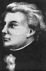
The survey plans for Washington DC were drawn up by a French Engineer named Major Pierre Charles L'Enfant (August 2, 1754 – June 14, 1825) L'Enfant was best known for designing the layout of the streets of Washington, DC. in what is known as the L'Enfant Plan.
Early life:
L'Enfant studied art at the Royal Academy in the Louvre, as well as with his father at the Royal Academy of Painting and Sculpture. He left school in France to enlist in the American Revolutionary War on the side of the rebelling colonials.
Military service:
L'Enfant arrived in the colonies in 1777 at the age of 23, and served as a military engineer in the Continental Army with Major General Lafayette. He was commissioned as a captain in the Corps of Engineers in 1779. L'Enfant served on General George Washington's staff at Valley Forge. While there, the Marquis de Lafayette commissioned L'Enfant to paint a portrait of Washington. L'Enfante was wounded at the Siege of Savannah on October 9, 1779. He recovered and became a prisoner of war at surrender of Charleston, South Carolina on May 12, 1780. He was exchanged in November 1780 and served on General George Washington's staff for the remainder of the Revolutionary War. L'Enfant was discharged when the Continental Army was disbanded in December 1783. After the war, L'Enfant designed the badge of the Society of the Cincinnati, an organization of former officers of the Continental Army, shaped as an eagle, at the request of Washington. He was sent to France to have insignias made for members of the Society, a group of veterans of the war.
Architect and planner Post–Revolutionary war:
Following the American Revolutionary War, L'Enfant established a successful and highly profitable civil engineering firm in New York. He achieved some fame as an architect by redesigning the City Hall in New York for the First Congress Federal Hall. He also designed coins, medals, furniture and houses of the wealthy, and he was a friend of Alexander Hamilton. . While L'Enfant was in New York City, he was initiated into Freemasonry. The new Consitution of the United State, which took effect in March and April 1789, gave the newly organized Congress of the United States authority to establish a federal district up to ten miles square in size. L'Enfant had already written to first President George Washington, asking to be commissioned to plan the city, but a decision on the capital was put on hold until July 1790 when the First Congress passed the "Residence Act", setting the site of the new federal district and national capital to be on the shores of the Potomac River. We have already seen how the federal district has been used by unscrupulous lawyers to try and undermine the Constitution of 1789 and the separation of powers.

Washington DC's stinky past
The idea was that the creek could be widened and channeled into a canal to the Potomac. By 1815 the western portion of the creek became part of the Washington City Canal, running along what is now Constitution Avenue. By the 1870s, however, because Washington had no separate storm drain and sewer system, the Washington City Canal was notoriously stinky. It had become an open sewer. When Alexander "Boss" Shepherd joined the Board of Public Works in 1871, he and the Board engaged in a massive, albeit uneven, series of infrastructure improvements, including grading and paving streets, planting trees, installing sewers and laying out parks. One of these projects was to enclose Tiber Creek/Washington City Canal. A German immigrant engineer named Adolf Cluss, also on the Board, is credited with constructing a tunnel from Capitol Hill to the Potomac "wide enough for a bus to drive through to put Tiber Creek underground." Many of the buildings on the north side of Constitution Avenue apparently are built on top of the creek, including the Internal Revenue Service Building, part of which is built on wooden piers sunk into the wet ground along the creek course. The low-lying topography there contributed to the flooding of the National Archives Building that forced their temporary closure beginning in late June 2006.
In fact, until the mid-1990s, that part of Washington around the intersection of 14th Street and Constitution Avenue was an open parking lot because the underground water was too difficult to deal with. During construction of the Ronald Reagan Building (1990–98), the engineers figured out how to divert the water. But that dewatering then reduced the water level underneath the IRS building which caused the wooden piers to lose stability and part of the IRS building foundation to sink. A pub near Tiber Creek's historic course north of Capitol Hill was named after it. The Bistro Bis restaurant now occupies the Tiber Creek Pub's former location. A lock keeper's house from the Washington branch of the Chesapeake and Ohio Canal remains at the southwest corner of Constitution Avenue and 17th Street, NW, near the former mouth of Tiber Creek, and the western end of the Washington City Canal. So you can see how stinky Washington on the Potomac became part of the David Carroll real estate deal, through family connections and George Washington's inside dealings.
In fact, until the mid-1990s, that part of Washington around the intersection of 14th Street and Constitution Avenue was an open parking lot because the underground water was too difficult to deal with. During construction of the Ronald Reagan Building (1990–98), the engineers figured out how to divert the water. But that dewatering then reduced the water level underneath the IRS building which caused the wooden piers to lose stability and part of the IRS building foundation to sink. A pub near Tiber Creek's historic course north of Capitol Hill was named after it. The Bistro Bis restaurant now occupies the Tiber Creek Pub's former location. A lock keeper's house from the Washington branch of the Chesapeake and Ohio Canal remains at the southwest corner of Constitution Avenue and 17th Street, NW, near the former mouth of Tiber Creek, and the western end of the Washington City Canal. So you can see how stinky Washington on the Potomac became part of the David Carroll real estate deal, through family connections and George Washington's inside dealings.
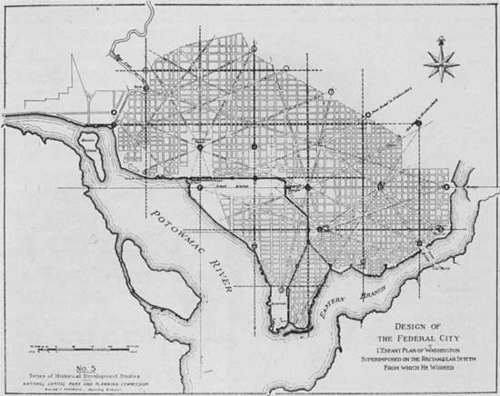
L'Enfant's plan
The U.S. Library of Congress now holds both the plan that Washington apparently gave to the Commissioners and an undated anonymous survey map that the Library considers L'Enfant to have drawn before August 19, 1791. The survey map may be one that L'Enfant appended to his August 19 letter to the President.
L'Enfant's "Plan of the city intended for the permanent seat of the government of the United States..." encompassed an area bounded by the Potomac River, the Eastern Branch, the base of the escarpment of the Atlantic Seaboard Fall Line, and Rock Creek. His plan specified locations for the "Congress house" (the Capitol), which would be built on Jenkins Hill, and the "President's house" (the White House), which would be situated on a ridge parallel to the Potomac River. L'Enfant envisioned the President's house to have public gardens and monumental architecture. Reflecting his grandiose visions, he specified that the President's house would be five times the size of the building that was actually constructed. Emphasizing the importance of the new nation's legislature, the Congress house would be located on a longitude designated as 0,0° (L'Enfant's plan contained the following explanatory note:
"In order to execute the above plan, Mr. Ellicott drew a true meridian line by celestial observation, which passes through the area intended for the Congress-House; this line he crossed by another line due east and west and which passes through the same area. These lines were accurately measured, and made the basis on which the whole plan was executed. He ran all the lines by a transit instrument, and determined the acute angles by actual measurement, and left nothing to the uncertainty of the compass. "
The plan specified that most streets would be laid out in a grid. To form the grid, some streets would travel in an east-west direction, while others would travel in a north-south direction. Diagonal avenues later named after the states of the union crossed the grid.The diagonal avenues intersected with the north-south and east-west streets at circles and rectangular plazas that would later honor notable Americans and provide open space.
L'Enfant laid out a 400 foot (122m)-wide garden-lined "grand avenue," which he expected to travel for about 1 mile (1.6 km) along an east-west axis in the center of an area that would later become the National Mall. He also laid out a narrower avenue (Pennsylvania Avenue,) which would connect the Congress house with the President's house. In time, Pennsylvania Avenue developed into the capital city's present "grand avenue." L'Enfant's plan additionally laid out a system of canals (later designated as the Washington City Canal) that would pass the Congress house and the President's house. One branch of the canal would empty into the Potomac River south of the "President's house" at the mouth of Tiber Creek, which would be channelized and straightened.
L'Enfant secured the lease of quarries at Wigginton Island and along Aquia Creek in Virginia to supply stone for the foundation of the Congress house in November 1791. However, his temperament and his insistence that his city design be realized as a whole, brought him into conflict with the Commissioners, who wanted to direct the limited funds available into construction of the federal buildings. In this, they had the support of Thomas Jefferson.
During a contentious period in February 1792, Andrew Ellicott, (who had been conducting the original boundary survey of the future District of Columbia) and the survey of the federal city under the direction of the Commissioners, informed the Commissioners that L'Enfant had not been able to have the city plan engraved and had refused to provide him with the original plan (of which L'Enfant had prepared several versions). Ellicott, with the aid of his brother, Benjamin Ellicott, then revised the plan, despite L'Enfant's protests. Some of Ellicott's revisions, such as the straightening of the longer avenues, created minor changes to the city's layout, including the removal of Square No. 15 from L'Enfant's original plan. Shortly thereafter, Washington dismissed L'Enfant. After L'Enfant departed, Andrew Ellicott continued the city survey in accordance with the revised plan, several versions of which were engraved, published and distributed. As a result, Ellicott's revisions subsequently became the basis for the capital city's development.

 RSS Feed
